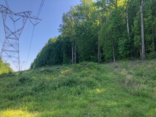
Cushetunk Mt Preserve Conditions

Patrick

Overthinking the draft from the basement already
Staff member
Can we just do that one climb and then leave and go to Sourlands?

No - i have to have you blow away that other tech section i was complaining about first.

i never did put together the video - I've come close to cleaning it after my early rant.
 

FitmanNJ

Well-Known Member
From the Railroad Lot, the trails were surprisingly dry today — no mud. On the other hand, there are a ton of twigs, branches, and other debris. I cleaned up as many spoke and derailleur hanger busting sticks and branches as I could between the lot and the end of the Eagle Trail (In think that’s what it’s called — the one only open between ~8/1 and 12/31, if I recall correctly). There’s one big tree down maybe 200-300 yards in from the lot; another big tree came down and is blocking the trail at the intersection of the Blue(?) Trail and the fall-line climb to the “saddle” (about 2/3rds of the way up); finally, there are 2-3 huge trees that came down together near the end of what I’ve called the Eagle Trail. Stacked vertically, they’re probably ~4‘ high — will definitely require a chainsaw.
 

Patrick

Overthinking the draft from the basement already
Staff member
From the Railroad Lot, the trails were surprisingly dry today — no mud. On the other hand, there are a ton of twigs, branches, and other debris. I cleaned up as many spoke and derailleur hanger busting sticks and branches as I could between the lot and the end of the Eagle Trail (In think that’s what it’s called — the one only open between ~8/1 and 12/31, if I recall correctly). There’s one big tree down maybe 200-300 yards in from the lot; another big tree came down and is blocking the trail at the intersection of the Blue(?) Trail and the fall-line climb to the “saddle” (about 2/3rds of the way up); finally, there are 2-3 huge trees that came down together near the end of what I’ve called the Eagle Trail. Stacked vertically, they’re probably ~4‘ high — will definitely require a chainsaw.

Cush side is clear. (maybe not the one on white, if it is below the blue intersection)

Eagle trail still has that one mess.

1597018974167.png
 

Patrick

Overthinking the draft from the basement already
Staff member
Got a mess on the trail that @Norm restored. It is now blazed blue on the railroad lot side of the impossible climb.
Go around it high-side for now. I'll get to it.

Lower yellow, and white climb is clear.

1598223775628.png
 

Norm

Mayor McCheese
Team MTBNJ Halter's
On blue? We hiked it today and it was totally clear. Or is this on the other side of the impossible climb?
 

Norm

Mayor McCheese
Team MTBNJ Halter's
it looked fresh!

Ok so I looked at your loop & start time. You were there before us, we followed. We walked up that blue trail, it was clean. Few hours later you come through on the way back to your car and it has fallen in between us being there and you being there. We went out the other way, eagle to fence then top of ridge & drop down to car.
 

Patrick

Overthinking the draft from the basement already
Staff member
Ok so I looked at your loop & start time. You were there before us, we followed. We walked up that blue trail, it was clean. Few hours later you come through on the way back to your car and it has fallen in between us being there and you being there. We went out the other way, eagle to fence then top of ridge & drop down to car.

so you put it there? thanks :D
 

Patrick

Overthinking the draft from the basement already
Staff member
The blue trail in cush (railroad lot side) is now clear.
Strangely enough - another tree fell in the woods nearby.
I heard it, but i was there, so the old conundrum still holds.

Pics above are from the eagle trail. While it was a mess, it was very predictable.
You can see the logs on the right are floating a bit. They were levered over a pile of rocks,
so would never make it to the ground. Work from the left dropping off movable pieces.

Also, never ever take your bike between the saddle and the top of the climb out of the lot.
@Norm said never take your bike there, but did i listen. Noooo!
If you feel the need to ride out the eagle trail then climb to the ridge, turn down to the parking lot
(which is a straight, DH run where you could kill people) or turn back to the water (which is a straight, DH
run where you could kill yourself.)

If you'd like a challenging hike, with some interesting rocks to climb - by all means, have at it.
I need to get @Robin or @Roadie up there to explain some of the rocks - very cool.

1598309666386.png


Oh, while i was up on the ridge, i met Melanie (?) - she is a NICA mom with the Hunterdon Havoc.
Lives on Old Mountain Rd, with backyard access to RV! wow. She knew @ilnadi and "lil nadi" (his rapper name)
She was very nice - knew about mtbnj.com - didn't make a face, i'll call that a win!
 
Last edited:

Roadie

Well-Known Member
The blue trail in cush (railroad lot side) is now clear.
Strangely enough - another tree fell in the woods nearby.
I heard it, but i was there, so the old conundrum still holds.

Pics above are from the eagle trail. While it was a mess, it was very predictable.
You can see the logs on the right are floating a bit. They were levered over a pile of rocks,
so would never make it to the ground. Work from the left dropping off movable pieces.

Also, never ever take your bike between the saddle and the top of the climb out of the lot.
@Norm said never take your bike there, but did i listen. Noooo!
If you feel the need to ride out the eagle trail then climb to the ridge, turn down to the parking lot
(which is a straight, DH run where you could kill people) or turn back to the water (which is a straight, DH
run where you could kill yourself.)

If you'd like a challenging hike, with some interesting rocks to climb - by all means, have at it.
I need to get @Robin or @Roadie up there to explain some of the rocks - very cool.

View attachment 137895
Oh, while i was up on the ridge, i met Melanie (?) - she is a NICA mom with the Hunterdon Havoc.
Lives on Old Mountain Rd, with backyard access to RV! wow. She knew @ilnadi and "lil nadi" (his rapper name)
She was very nice - knew about mtbnj.com - didn't make a face, i'll call that a win!
I think that would probably be an igneous rock called Diabase that is similar to what makes up the Palisades Sill. Especially if its at a higher elevation.
 

rxb6170

New Member
What is the best way out of railroad parking lot to get over to round valley, without having to take white trails straight up?
 

Patrick

Overthinking the draft from the basement already
Staff member
What is the best way out of railroad parking lot to get over to round valley, without having to take white trails straight up?

You've come to the right place! One of these days, i'm going to make a video....

Leave the lot along the pipeline, about 50 yards down the trail goes into the woods.
Out to white, start climbing, right on yellow, left on blue - Hike bike over the top of white

i'm eyeballing a spur off blue to make the climb to the top rideable for regular people.
stay tuned. (probably would do this before video!)

In this one, we ride from Pickell Park to the railroad lot, then go into the woods
from the pipeline entrance.

 
Last edited:

rxb6170

New Member
You've come to the right place! One of these days, i'm going to make a video....

Leave the lot along the pipeline, about 50 yards down the trail goes into the woods.
Out to white, start climbing, right on yellow, left on blue - Hike bike over the top of white

i'm eyeballing a spur off blue to make the climb to the top rideable for regular people.
stay tuned. (probably would do this before video!)

In this one, we ride from Pickell Park to the railroad lot, then go into the woods
from the pipeline entrance.

Thank you 👍
 

Trail Conditions

Current Conditions

powered by Trailforks.com
Top Bottom