Round Valley Conditions

Clapper beat me to it

Question on Cushetunk lot
Which hill is the hike a bike trail you are referring? Went there 3 weeks ago when the trails were unrideable. The trail, I think blue under the power wires had too much snow and the other, white?, was closed. Is that the trail that's closed from Jan to Oct
 

The White Trail is the one with the hike a bike at the very end just before you enter Round Valley Park. Many cheapskates like myself deal with the hike a bike to avoid paying the Round Valley summer parking fee. The Eagle Trail is the one that is closed January to August.


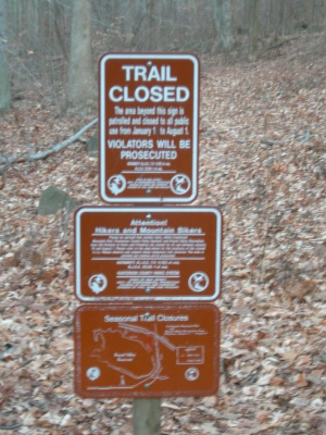
A Stern Warning Awaits You
The Eagle Trail is a trail in Round Valley State Park and is so called because of the current, or former, presence of eagles out in the far reaches of the park. The trail is closed from Jan 1 through Aug 1 in an effort to keep the influence of humans from the eagles. Technically the nest is, or was, in Cushetunk Preserve, but the farthest extension of the trail in Round Valley proper is also closed. Signs in the area indicate the presence of an endangered species. A sign at the head of the trail announces the seasonal trail closure, as well as in 2 places at the top of the ridge.
There was some talk recently that the eagles have since left the reservoir but this report has not been confirmed as fact or fiction. The second picture shows what the trail looked like in December 2009, in any of several places. The trail has collected considerable blow-downs and at this writing cannot be considered remotely passable. It would appear that the park is letting this trail close itself as the trees have clearly been down for some months.
The trail used to be mostly rideable save for the end, which turns abruptly and heads up a very steep climb and enters Cushetunk Preserve. The park map also suggests that a trail goes along the base of the ridge and continues to the closed water management area, though no sign of this trail seems to exist.


Funny. Looks like I probably wrote that. No real memory of that at all.
 
It was just beginning to sprinkle when I got to Round Valley this morning. The trails were wet and a bit slippery, but not muddy. After the ride, there were a lot of wet leaves plastered to my bike frame, but little dirt/mud. It remains to be seen how much more rain the trails there will get -- and how it will affect them -- but as of Friday morning, I rated Round Valley a "3."
 
For reference, I rode yesterday. Would you rate them a 3 against other trails in the area or a 3 due to a couple soft spots and wet leaves?
Yesterday I would give them a 9 out of 10. -1 for the hills that didn't melt. Best dirt I've seen in a while. My opinion..
 
Rode there today and saw FitmanNJ at the intersection of the Eagle Trail. (I was w/ Mark on the Black Salsa Fatness) As said above, it was pretty good with a very few soft spots, but it got a little slippery after a bit of rain. Overall, probably better than anything else in the area. I gave a rating of a 3.
 
For reference, I rode yesterday. Would you rate them a 3 against other trails in the area or a 3 due to a couple soft spots and wet leaves?
Yesterday I would give them a 9 out of 10. -1 for the hills that didn't melt. Best dirt I've seen in a while. My opinion..
Solo: "3" due to wet leaves/roots/rocks. Certainly not bad...
 
Rode there today and saw FitmanNJ at the intersection of the Eagle Trail. (I was w/ Mark on the Black Salsa Fatness) As said above, it was pretty good with a very few soft spots, but it got a little slippery after a bit of rain. Overall, probably better than anything else in the area. I gave a rating of a 3.
Good to see you and Mark out there at Round Valley today, GoodVibe -- I didn't recognize you without the makeup.😉 Wish I could have stayed with you guys, but the lungs don't have the capacity on that rocky/hilly terrain!
 
Agree with the 3/4 rating
some standing water on top of Puke hill and on red the last mile back to South
Got in at about 2pm and out at 4:30

found myself lost a bit by the campgrounds
there's a 3 way fork with signs right and left to campgrounds, I went straight, which put me on a steep downhill to the lower campgrounds

Road on the boyscout trail till a small brown house, where I believe is the trail to the Cushetunk lot
ran into two guys who pointed me back to the south lot, think this was the red trail

Pretty sure I now know which climb is Puke Hill, only made it halfway if lucky
Stayed on red all the way back, which was different from how I got to the campground from the newly landscaped area
the way back after the dam was more than I could really handle as I was pretty tired

really got beat up on RV today, first goal is to get up Puke Hill by summer
 
Rode the out and back today and it was awesome... 2 wet spots that lasted at most 20 feet, other than that it was bone dry (4/4). On a side note: is there a way to bypass the waterbar climb? Hiking that was killer..
 
Rode the out and back today and it was awesome... 2 wet spots that lasted at most 20 feet, other than that it was bone dry (4/4). On a side note: is there a way to bypass the waterbar climb? Hiking that was killer..

The one just after the dam running along the fence (this would be a return trip from the RV parking lot)? If so, yes - there are switchbacks under the power lines -
from the base of the dam, it starts off to the left of the field - from the top, it is a right hand turn before going under the powerlines.

if you mean the one after the fireroad (this would be on the out) - no. but you probably didn't mean this one...
 
Last edited:
@phillychris498; if the waterbar climb is the where newish railroad ties which were added recently to control erosion
fidodie's alternate route is it, you'll be going through a fenced section to get there
I still needed to hike quite a bit there as well, but the better rider will be fine
 
Heavy rain today and the park was awesome , a little slippery on the rocks which added to the challenge .
 
+1
20150616_165639.jpg
 

Trail Conditions

Current Conditions

powered by Trailforks.com
Back
Top Bottom