A little update on the work we did yesterday.
@pooriggy was in the field continuing with the fresh cut trail with some of the TM crew.
@smann , Andrew, UK Steve and I were in the woods up trail working on some of the water control.
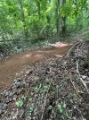
Pic of the area just as we started. The guys brought out some nearby rock for armoring and we ended up using about 20x more of this amount. The Grand Tour sign on the tree is good for perspective.
View attachment 238873
I noticed a lot of big stone sunken in when I previewed this area on Sunday to put some mental notes together for the Monday TM. The crew worked hard and this was the biggest of the stones we broke out. Andrew is not a small dude - it took all 4 of us with rock bar and shovel to pry it out and set in place.
View attachment 238875
The lads at it. These guys move fult tilt! The hole where the large stone was, was filled with the old quary stone that didn't do shit and was strewn all over the place. Having larger stone hold it in place should keep it in the right spot.
View attachment 238877
We popped out a half dozen more good sized rocks and continued with the drain wall. With that beautiful stone I felt like some organics on the right side of it would help hold the rocks in place, keep the water from breaching and going back on the trail and also look good. So we transplanted a few trees and ferns and added leaf matter to make a natural bed.
View attachment 238878
The guys had to leave so I stayed for a little more to massage the final rocks in place. Like the Jims they are such beauts that they wanted to help bang it out but it's more mental/jigsaw work and doing it solo wasn't too bad.
View attachment 238879
This is what I came up with. Looks like mostly dirt but the amount of rock in there is huge. With rain and use the material shoudl filter down, lock things in place and create a nice texture for hiking and riding. All the while bringing the rain water off trail.
View attachment 238885
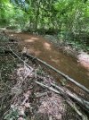
The view looking up the trail.
View attachment 238886
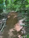
Broader view looking down trail
- blue arrow - runnel line that stayed on trail creating issues further down. We just followed the line straight for water exit
- yellow circle - where the old runnel line/trail - now some organics
- blue circle - new exit for water - the natural slope came down 2 ft
- white line - new bank and tread - the usable trail is wider now. It seemed it was getting pushed over between the loose quary stone and erosion and users looking for a smoother/drier line. I also banked it so it will be off camber for the water drain but then in slope to hold you for the second part as you get back on the main trail.
- red circle - Grand Tour marker sign
View attachment 238890