Yeah sorry about that it must have been the Leroy trail, I really just had a vague memory at the time. I don’t know the names as well as most others here- The other one I pointed out with gps was vital since it was blocking the trail like that. Thanks for your work!I went up the entire length of Skeezix all the way up Cooler, to the intersection with Green and did not find. I came back down Cooler (to Funyuns) and still didn't find. Disappointing. Keep eyes open for a tree that fits this description, that's NOT on Skeezix, or Cooler, Or the Nica trail, or Trestle.


You are using an out of date browser. It may not display this or other websites correctly.
You should upgrade or use an alternative browser.
You should upgrade or use an alternative browser.
Stephens State Park Conditions
- Thread starter pedals
- Start date
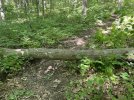
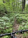
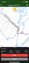
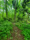
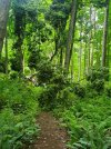
Here’s a picture of the tree on leeroy and locationBridge is under water, but you can still ride over it. Kind of a cool feature while it lasts.
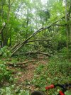
Two trees down that I saw. Apologies for no photos and markings are approximate. One on Leroy is larger of the two and probably needs an 18"er to make it easy to cut. Both are elevated off the ground by a foot or two.
There is definite evidence of trimming on some trails. The less popular (but still good!) trails to the southwest are getting overgrown; blue, parts the white around that area, etc.
View attachment 239605
Attachments
chainsawer
Well-Known Member
Thx. tracking!
chainsawer
Well-Known Member
I cleared that one tonight. Thanks for the Intel!Here’s a picture of the tree on leeroy and location
chainsawer
Well-Known Member
Out of curiosity, is there anyone in the ranks who'd be interested in assisting me on chainsawing missions? The formal term for it is "swamper". As you'd expect, your primary role would be to help clear whatever's been cut. You'd also be another set of eyes for improved safety. I already have a couple of people on the list, but their availability is limited, therefore I'm trying to increase the pool of willing participants. The parks I service: Dickerson Mine, Stephens,. Deer Park, Allamuchy North and sometimes Mahlon Dickerson. DM me if interested!
chainsawer
Well-Known Member
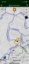
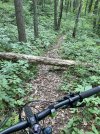
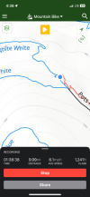
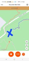
Cleared that one tonight (actually on Pre-cooler), what a mess! I also cleared big ones on "Land of the lost", "Swamp & Chop", and a pair on the upper mulch pit trail. This catches me up with all known issues in Stephens. Next focus to be on Allamuchy North, Eastern side..Large tree down top of cooler trail. See attached pic & map.
Last edited:
chainsawer
Well-Known Member
Thx for the excellent Intel. Tracking.
chainsawer
Well-Known Member
Got them this evening, before I did a few over in Allamuchy North. Thx again for the intel.Only two I saw on today’s ride, both locations are close to each other at least. Pots and pans.
Jrzjoe
Well-Known Member
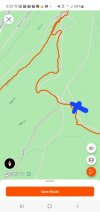
beat me to it. thats all i saw today. did a bunch.Tree down at the end of the Trestle trail just before the maze area. See attached map & pic.
Teutonic
Well-Known Member
I texted him before both of you guys, but I didn't have a nice picture like AS4321 did!beat me to it. thats all i saw today. did a bunch.
On the climb up to tee pee rock, the short section past a large rock and through a rock garden (if four rocks can be called a rock garden) where the line has been for the last 10 years. Until a cheater line to the left of the tree showed up late last year. not sure of the back story, but is there any real reason for the the original line to be closed up with branches? Or just another instance of trail sanitization?
Teutonic
Well-Known Member
We noticed that yesterday as well. Not sure why we can't have both lines?--I prefer the original line.On the climb up to tee pee rock, the short section past a large rock and through a rock garden (if four rocks can be called a rock garden) where the line has been for the last 10 years. Until a cheater line to the left of the tree showed up late last year. not sure of the back story, but is there any real reason for the the original line to be closed up with branches? Or just another instance of trail sanitization?
chainsawer
Well-Known Member
The one at the end of trestle trail has been cleared. Thanks to DK for the help.
It's the classic battle ofOn the climb up to tee pee rock, the short section past a large rock and through a rock garden (if four rocks can be called a rock garden) where the line has been for the last 10 years. Until a cheater line to the left of the tree showed up late last year. not sure of the back story, but is there any real reason for the the original line to be closed up with branches? Or just another instance of trail sanitization?
Can do's vs Can Not's
The Can Not comes up and finds that the Can Do piled a bunch of wood on his special line. So like a good Can Not he moves that pile into Can Do's special line. Then like all good Human Monkeys do, they place that special wood pile in its right place upon arrival 😁
Which Monkey are you, figuratively of course, not at the poster.
Last edited: