lol yellow is essentially the perimeter and intersect with almost everything.Rode today. Roads were a little soft but the trails were good. Got home and only my tires were dirty. Why are so many of the trails yellow? 😩


You are using an out of date browser. It may not display this or other websites correctly.
You should upgrade or use an alternative browser.
You should upgrade or use an alternative browser.
Lewis Morris Conditions
- Thread starter mcim29
- Start date
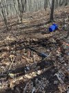
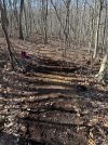
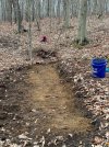
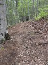
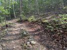
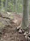
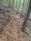
Muddy with the warm temps but allowed me to remove the stump and fill in the hole in the middle of new orange. New dirt is gonna be a little soft until it gets completely packed in.
Attachments
@Id_rather_be_skiing
Using a roto-tiller is very helpful in cutting roots and breaking up the thatch layer. Once the ground is busted up, it's easier to bench grade.

Using a roto-tiller is very helpful in cutting roots and breaking up the thatch layer. Once the ground is busted up, it's easier to bench grade.
I wish…I was specifically told no machines, must be a liability thing for MCP. I was thinking of using a hand thatcher I have for my lawn.@Id_rather_be_skiing
Using a roto-tiller is very helpful in cutting roots and breaking up the thatch layer. Once the ground is busted up, it's easier to bench grade.
View attachment 206968
Monday, Feb 20
Completely dry.
No post ride cleanup required

Completely dry.
No post ride cleanup required
Greg-O
Member
Yup, that's why it's affectionately known as the "Roadies Mtb Course"! Not as much fun as my usual Sterling or Ringwood, but if you just want a day in the saddle with miles without getting pounded, then it's perfect for that. I still occasionally ride there and love going into Morristown afterwards!
Yes exactly. It is a beginner park and great for logging miles. If you want chunk head north. We're doing our best to make it a fun place to ride that isn't just roots.Whelp, I finally got down to this park today. Trails are fine, and the new ones are a bit fun. It's kinda a xc park, isn't it?
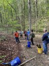
8 participants today for the trail maintenance. We worked on the downhill of orange to the bridge. Still a lot of work to do. Next maintenance day is June 3rd national trail day.
Attachments
WickedSistahEast
Well-Known Member
Tree down on upper green. @Id_rather_be_skiing is aware.
SAM
Well-Known Member
What is the deal with the part of Green Trail that runs across Doe Meadow Road to the picnic area and MTB lot? I think this trail has only been there a few years. I wonder what sensitive environmental features in this area are being adversely impacted by access to the trail?
I looked at Trailforks and there are no warnings or closures listed. Trail had 16 rides in the past week, according to "Recent Ridelog Activity". I didn't ride it but noticed when I got to the picnic area/MTB lot that there are no signs or barriers blocking the trail entrances on that end.

I looked at Trailforks and there are no warnings or closures listed. Trail had 16 rides in the past week, according to "Recent Ridelog Activity". I didn't ride it but noticed when I got to the picnic area/MTB lot that there are no signs or barriers blocking the trail entrances on that end.
I was under the impression that only the section circled in red would be closed to allow reforestation of that field. There were signs to this effect at the southern end of that trail for a few months prior. Are you saying that the entire green trail (all the way to the parking lot above the lake) is closed? That would be a surprise since some of that is new trail cut by MCPC in the last two years.

SAM
Well-Known Member
Thanks for the clarification. There were signs at the southern end (entry from Green dot or Red trail). There were also signs at the access from the trail that comes off Orange (Trail not shown on Trailforks). No signs at the north end of the trail at the entrances near the picnic area and parking lot, as I mentioned.
I approached the trail from the south as an exit to the MTB Parking Lot at the end of my ride, which this trail is perfect for. It was not clear how much of the "area" and trail was closed from the signage.
A map of the area closed on the sign would've helped although it doesn't matter much since there is no other access to the trail from the south. I guess it has to be ridden as an out and back from the north entrances near the Picnic area or parking lot, which doesn't make a lot of sense to me. I guess I'll have to do that if I want to ride that trail next time.
I should clarify…the closed section should only be the section in the open field. The gravely fire road up to the crossing with Doe Meadow road should be fine. So, from where you saw the sign you could ride the section I’ve marked in red. Does that make sense?

SAM
Well-Known Member
Okay. Thanks. I looked down there from the intersection with Blue and saw the same signs and fencing. So, I assumed it was blocked but I did not ride down there to look. Now I see that the left turn to cross Doe Meadow might've been open. I should've ridden down there to check but saw lots of signs and fencing, so thought it was shut.
After this past weekend's group ride, i noticed the purple/bombs away/tingly trails were in dire need of a cleanup so this morning while on a 4hr work call I did the needful to the left side of below loop. Yay multitasking. All trimmed, clear of blowdowns and awkward logs. The flow is ready to go.
