liong71er
Well-Known Member
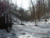
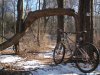
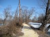
yesterday,...rode both of this trails using canal tow path as connector.
and some vids of me riding on red towards white trails (middlebush) at six mile then more at chimney rock's frozen lakes...
"keep your eyes peel on the rear wheel" it will give you "star wars" kind a feel..😀http://www.youtube.com/watch?v=qefKtDjkzCk
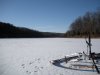
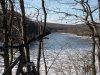
"frozen lakes"....
http://www.youtube.com/watch?v=jffIaLrPHRs
GPS http://connect.garmin.com/activity/22158903
sorry,folks.no music here!(coz i'm dumb)
and some vids of me riding on red towards white trails (middlebush) at six mile then more at chimney rock's frozen lakes...
"keep your eyes peel on the rear wheel" it will give you "star wars" kind a feel..😀http://www.youtube.com/watch?v=qefKtDjkzCk
"frozen lakes"....
http://www.youtube.com/watch?v=jffIaLrPHRs
GPS http://connect.garmin.com/activity/22158903
sorry,folks.no music here!(coz i'm dumb)
Attachments
Last edited: